


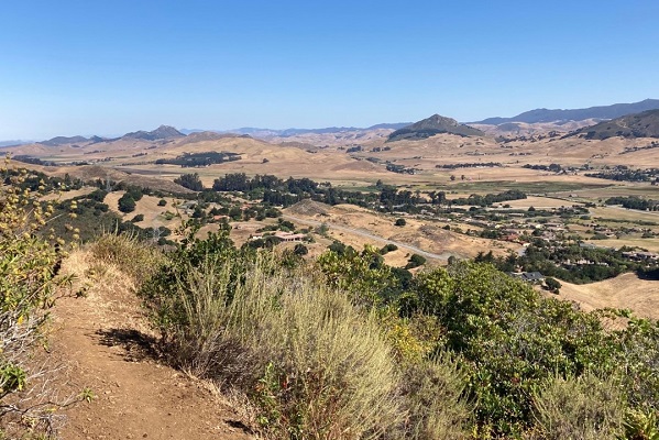
Photo courtesy City of San Luis Obispo
Trail adds a new picturesque loop to a 9-mile trail system
—The City of San Luis Obispo recently completed the 1.3-mile Bog Thistle Trail in the Irish Hills Natural Reserve. The new trail extends the former 0.4-mile trail and hikers can now travel from the Perfumo Canyon trailhead to the Mariposa and the Mine trails. The extended Bog Thistle Trail creates a 3.4-mile intermediate-level hike that loops back to the trailhead or gives hikers the option of longer hikes on the connecting trails.
Hikers can expect sweeping views of the Morros, Laguna Lake, Los Osos Valley and a path through picturesque oak canopy and chaparral habitats. Designated as a hiking-only trail, the Bog Thistle Trail plays a vital role in promoting a quality multi-use trail system and provides an alternative route for hikers to access the Irish Hills Natural Reserve trail system from Prefumo Canyon Road.
The Irish Hills Natural Reserve interconnecting trail system meanders through 720 acres of riparian, grassland, oak, chaparral and serpentine habitats. The reserve is home to a variety of California wildlife including deer, coyotes, snakes, thousands of birds and mountain lions.
Irish Hills is named after Irish immigrants who moved into the area in the 1800s. The old schoolhouse is still standing at the trailhead and evidence of their farms can still be seen in some locations. Chromium and mercury mines operated in the area in the 20th century and some remains of the mining operations are still present. Major trails in the Irish Hills Natural Reserve connect into a larger trail system operated by the City of San Luis Obispo that accesses thousands of acres of natural reserves and open spaces. The new Bog Thistle Trail also provides access to the larger trail system from the Mariposa Trail.
The new trail was made possible by planning and coordination between Park and Recreation’s Ranger Service and the Office of Sustainability and Natural Resources and the dedication of a core group of skilled volunteers who contributed over 900 hours of work. Special attention and care went into safeguarding scenic views, mature oak trees, and waterways. To protect potentially sensitive habitats and species, the Ranger Service conducted field botanical surveys to identify any sensitive species listed by the California Native Plant Society, as well as state and federally-listed threatened and endangered species.
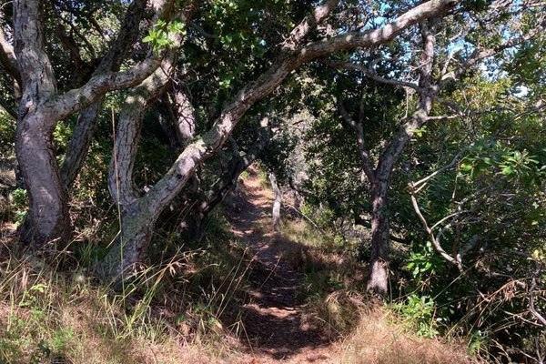
Photo courtesy City of San Luis Obispo
More great hiking around San Luis Obispo
San Luis Obispo is rich with trails for viewing wildlife, native vegetation and panoramic views of the coastline, valleys and mountains. The city has preserved the natural beauty and resources of thousands of acres of open space for the enjoyment of the public. Many include cycling access and most are leashed dog friendly, but some of the trails can be challenging to a dog or a person not in good physical shape.
Trail maps and more information about open spaces and hiking trails are available online from the Parks and Recreation Department Ranger Services or call (805) 781-7300.
In addition to enjoying the Irish Hills trail system, here are more hiking and cycling trails that are easily accessed from San Luis Obispo.
Bishop Peak Natural Reserve
Bishop Peak is the highest of the Nine Sisters volcanic peaks spanning 12 miles between San Luis Obispo and Morro Bay. This reserve has two interconnecting trails totaling nearly 8 miles with varying degrees of difficulty.
Cerro San Luis Natural Reserve
Cerro San Luis is a 1292-foot peak in the Nine Sisters volcanic chain. Cyclers and hikers are allowed on the 2.1-mile Lemon Grove Loop. Hiking only is recommended for the “M” Trail, a 2.6-mile loop and a 640-foot climb. The trails merge for about a half-mile at one point. The trailhead is from Carriage Road.
Islay Hill Open Space
There are three different access points to the Islay Hill Trail, ending at 776 feet panoramic view of Edna Valley and the Santa Lucia Mountains from this peak in the Seven Sisters formation. Trailheads are from Sweet Bay Lane, Spanish Oaks Drive or Huckleberry Lane.
Johnson Ranch Open Space
The Johnson Ranch Loop is a two-segment trail. The 2.6-mile segment is recommended for cycling and the 2.3-mile segment for hiking. The Filipponi Connector leads hikers to trails in the Irish Hills Nature Reserve. The trailhead is just off of Highway 101 between San Luis Obispo and Pismo Beach.
Laguna Lake Natural Reserve
Four intersecting trails bring hikers and cyclists to Laguna Lake. Two trails, the Allen K. Settle trail and the Lakeside Trail are ranked as easy. Laguna Lake Upper Loop Trail is an intermediate trail. Laguna Lake Ridge Trail is expert only. The entrance is at 504 Madonna Road in San Luis Obispo.
Reservoir Canyon Open Space
Reservoir Canyon Trail is a 5.35-mile round-trip moderate to difficult hike through oak and eucalyptus groves, featuring waterways, a waterfall and 360-degree view from the top. Leashed dogs are welcome. Mountain bikes are prohibited.
Stenner Springs Natural Reserve
Stenner Springs Natural Reserve trail system has seven different trails that total little over 20 miles with varying levels of difficulty. The shortest trail, the Stenner Creek Trail to Elevator Trails is a 2.9-mile moderately challenging loop. The longest trail complex, which includes the Morning Glory, Botanical and Shooters Loop for hikers and mountain bikes is a challenging 9.3-mile loop that takes over four hours to complete.
Bob Jones Trail
This is a 5-mile family-friendly paved loop connecting San Luis Obispo and Avila Beach. Start at Ontario Road and walk or bike along the San Luis Obispo Creek, through the Avila Golf Course, enjoying shade from sprawling oaks along the way.
