


The chain of ancient volcanic peaks stretch from San Luis Obispo to the Pacific.
A chain of ancient volcanic peaks, which stretch from San Luis Obispo to the Pacific, provide a great chance for visitors to explore the outdoors. Known to locals by many names including the Nine Sisters, Cerros and Morros, the craggy mountains arose from the ocean approximately 25 million years ago and offer a wealth of geologic and scenic rewards.
Each of the peaks, Morro Rock, Black Hill, Cabrillo Peak, Hollister Peak, Cerro Romauldo, Chumash Peak, Bishop Peak, Cerro San Luis and Islay Hill were formed when volcanic plugs of magma welled up and solidified into softer rock. Over time the softer rock eroded away, leaving behind steep, rocky buttes that provide the area with a unique, natural skyline.
Several of the peaks are accessible to the public, however visitors should be forewarned that access might involve a hike through private property. While the landowners have adopted a lenient stance towards visitors, guests are asked to respect the land by packing out any items they may bring and leaving dogs behind in areas with grazing cattle.
Hike Cerro San Luis
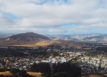
Named by the padres of Mission San Luis Obispo this mountaintop provides a fairly easy hike with views of San Luis Obispo and the Santa Lucia Mountains. Hikers and mountain bikers can find a trailhead by taking Higuera Street in San Luis Obispo and turning onto Marsh Street towards Highway 101.
Guests should go under the highway and turn right onto Fernandez Road just before the southbound 101 entrance to find the parking lot. The Lemon Grove Trail runs in a loop and is 2.2 miles roundtrip.
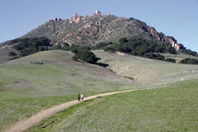
Hike Bishop Peak
The Nine Sisters arose from the ocean approximately 25 million years ago.
At 1,559 feet Bishop Peak is the tallest of the sisters, a distinction that results in the most strenuous hike along with the most gratifying views and photographic opportunities. A trailhead can be found off of Foothill Boulevard in San Luis Obispo and visitors should keep an eye out for the cars parked along the road between Los Osos Valley Road and Santa Rosa Street.
Another trailhead can be found by taking Foothill Blvd. west and making a right on Patricia Drive. Continue north and make a left on Highland Drive, which ends at the trailhead. This trail is about 4.2 miles roundtrip.
Those looking for a less strenuous hike can reach the Patricia Court trailhead by taking Foothill Blvd. west and making a right turn at Patricia Drive. Continue north to the Felsman Loop trail which is on the left just past Patricia Ct. The loop is 2.7 miles roundtrip and takes visitors around the base of the mountain.
Hike Black Hill and Cerro Cabrillo
Two of the peaks, Black Hill and Cerro Cabrillo, are found within Morro Bay State Park. Depending on your location access the park by taking Highway 1 north or south to the Los Osos – Baywood Park off ramp. Head southwest and turn right onto State Park Road.
Hike Black Hill
Hikers have two options to reach the summit of Black Hill, follow a trail which starts near the campground area or drive up Black Hill Road to a parking area a few hundred feet from the top. Those opting for the longer route, about three miles roundtrip, can get specific directions to the campground by asking the rangers at the information kiosk located at the park’s entrance.
For those who want to take the shorter route take Black Hill Road through the golf course. Make sure to stay on the left at the fork in the road as the road can easily overlooked because its resemblance to a golf course trail.
For a relatively short hike, .3 miles, the views are exceptional. Keep climbing to the top for a panoramic bird’s eye view of Morro Bay Harbor, Morro Rock the sand spit and wetlands.
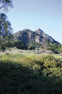
Hike Cerro Cabrillo
With an elevation of 911 feet Cerro Cabrillo is the highest point in the state park. Popular with both hikers and rock climbers the peak can be reached from East Bay Boulevard. To hike the around the south side of the peak enter through the gate located about .3 miles north of Turri Road.
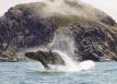
Morro Rock is closed to hiking
This dome-shaped rock is the most prominent landmark in Morro Bay. Recognized as both a natural preserve and state historical landmark visitors are not allowed to climb the 578 feet to the top, but can enjoy year round bird watching around its base.
